 bluecordfishermen
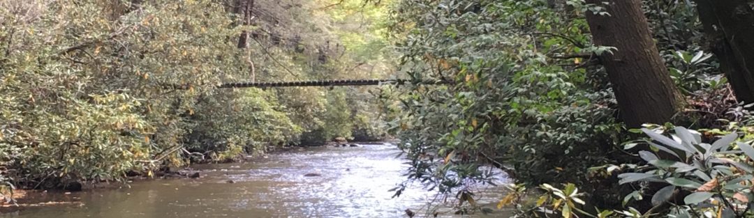
Stony Creek, Saint Anthony’s Wilderness. LAT / LONG: 40.420779 -76.745903
Background:
Saint Anthony’s Wilderness (State Game Land #211) is almost scared ground to me. I spent many days hiking, turkey hunting and camping along the trails and fishing Stony Creek as a much younger man. I learned fly fishing along Stony Creek and caught my limit on a few occasions. At one point, my college roommate and I spent a week living off the land in Stony Valley before our Freshman semester started. We lost some weight that week, but caught some natives the last day upstream from Cold Springs. Those stories never get old. Names like Rausch Gap, Cold Springs, Yellow Springs, Rattling Run, Stage Coach Trail, Devil’s Race Course and Water Tank Trail each bring back memories. This trail network is found in the second largest continuous forest in Pennsylvania. State Game Land #211 is so big it lies in two counties. I used those trails to prepare me for challenges like Ranger School and other feats of endurance. Climbing Water Tank Trail with a rucksack was always my milestone to see if I was ready to take on a challenge. Every trip to Stony Valley makes me a better man in some way or another. Many others agree.
Stony Valley was home to several communities in the early 1900’s. These were railroad and mining towns that became ghost towns when the mines stopped producing and the rail line was abandoned. What was left behind was a great access way into a wilderness. The following web pages offer some interesting history and observations. I recommend taking some time to look them over if you are not familiar with State Game Land #211.
http://www.stonyvalley.com/educate.html
https://visitlebanonvalley.com/business/gold-mine-road-trail-head/
http://www.midatlantichikes.com/rauschgap.htm
https://www.traillink.com/trail/stony-valley-railroad-grade/
Description:
Stony Creek is the run that lies between the second and third ridge lines of the Blue Mountains north of Harrisburg. This creek flows east to west and after about 21 miles, and drains into the east shore of the Susquehanna River at Dauphin [Lat/Long 40.365698 -76928837]. Stony Creek runs through State Game Land #211 with parking lot on the western edge at the end of a dirt road (Stony Creek Road) . An abandoned railroad bed parallels the creek all the way to Cold Springs where the creek meets a tributary that comes out of the north heads north in a gap and crosses Stage Coach Road. The railroad bed continues on to Gold Mine and beyond to High Bridge. There is one two rope bridge near Lat/Long 40.424084 -76.748271. This is an estimated location and you will have to stumble across it. This bridge is consist of two wire cables attached to trees and is the only dry way across the creek until Cold Springs Road in Lebanon County. The cables are taught but can make for an interesting traverse with a fly rod.
The valley between the second and third mountains gets its name for a reason. The valley floor is nothing but boulders. Trees grow between the rocks along with the mountain laurel. It is near impassible unless you can find a well traveled game trail or old logging road. Going cross country is very slow and comes with a lot of risk bounding from rock to rock. I have not been back in Stony since recent logging began so it’s possible that the logging roads on the south side of the creek will provide additional access.
Her sister creek runs in a similar fashion on the other side of the 3d ridge, north of Stoney Valley and is named Clark’s Creek. PA highway 325 parallels Clarks Creek and that makes it more accessible but has more fishing pressure. I always thought it attracted more than enough to fishermen to reduce the pressure on Stony.
Peter’s Approach to Access Stony Valley:
There are several ways to enter Stony Valley and each has its advantages and disadvantages. The fastest is to drive in from Dauphin on Stony Road to the trail head but of course that is the stretch that gets the most fishing pressure. Any hike in requires climbing over a significant mountain ridge line and will take at least 2 hours. The factors, to consider, boil down to available time and your level of physical fitness. Do not over extend yourself because the way out does not get easier after a full day in Stony Valley.
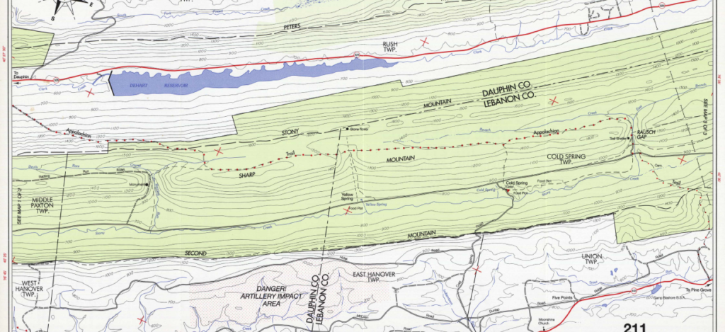
Option #1. DAUPHIN TRAIL HEAD. The old railroad bed is closed off to vehicle traffic but used to stock the creek. The Abandoned railroad bed allows easy walking up stream from the trailhead or riding a bike with fishing gear miles toward Cold Spring. The abandoned railroad bed goes all the way to Gold Mine and beyond to High Bridge in Lebanon County. The drive into Stony Valley from Dauphin on Stony Creek Road. Stony Creek road becomes dirt for the last mile or so. This road will allow normal sedans but it does have numerous pot holes and will force you to drive slow. Park at the trailhead in State Game Land 211 in vicinity of [LAT/LONG 40.403231 -76.835176]. After parking your vehicle, hike or bike east and move to a hole of your choosing. On the first day of trout season, expect the railroad bed to be a busy place. Parking at the trail head gets tight the first weekend of trout season.
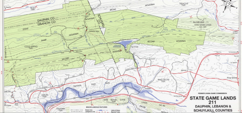
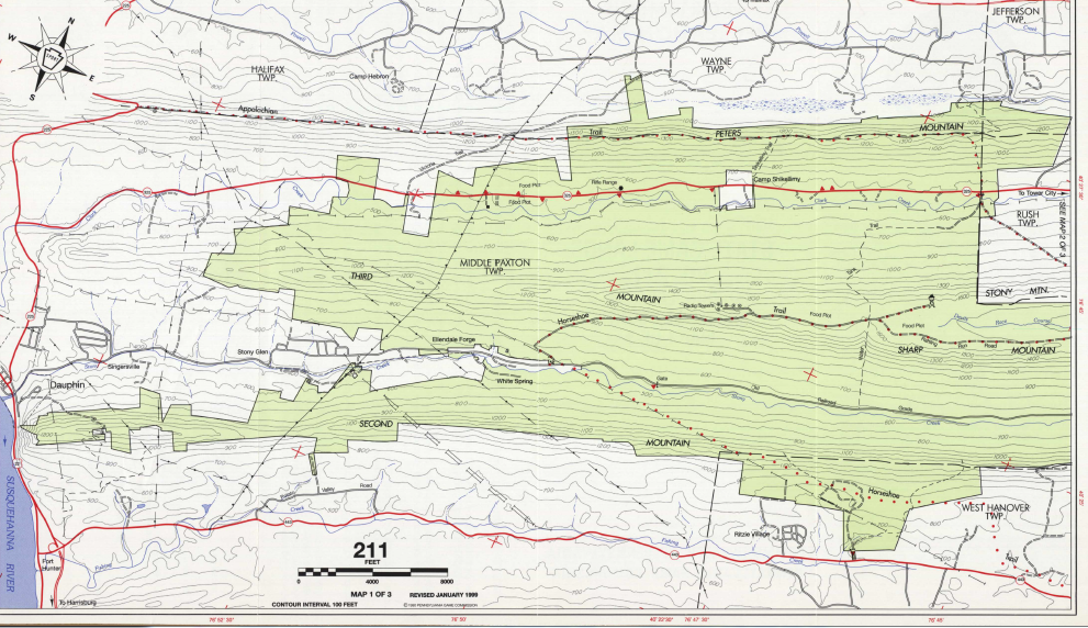
Option #2. COLD SPRINGS ROAD. The railroad bed can be reached using Cold Springs road heading north out of Indiantown Gap Military Installation. Follow the road signs to Hawk Mountain look out but continue over the mountain. The road on the other side of the 2d Ridge is extremely rough. I would not advise using anything but a 4x wheel drive and high suspension but perhaps the road has been repaired. Cold Springs Road crosses Stony Creek [LAT/LONG 40.476217 -76.62346]. In the past, trout stocking begins well to the west of Cold Springs. Cold Springs is home to a lot of foundations and the former site of Dresden Lake. The dam that was made up Dresden Lake can be seen while crossing the bridge over the stream.
Option #3. SWATARA GAP. The Appalachian Trail also allows foot traffic on the trail from PA Highway 443 North of Swatara Gap to Rausch Gap. This is at least a 2 hour hike and climbs the 2d Ridge. The path down is an old wagon road and is cut into the side of the mountain. This route is the “easiest climb” out of Stony Valley. You need to assess your physical fitness before using this route. The stream near Cold Springs has some tough fishing but I have caught natives near Cold Springs. The AT crosses Stony and makes use of a bridge at [LAT/LONG 40.505294 -76.566359]. Its 2.3 miles from Rausch Gap to Cold Springs hiking the railroad bed. There is a footpath that parallels the creek but it takes a winding route and sparsely marked.
Option #4. GOLD MINE ROAD TRAILHEAD. After the head waters of Stony creek are reached in the east beyond Rausch Gap, the valley changes its drainage to the east in Evening Branch Creek. This small creek empties in the Lebanon Reservoir (High Bridge). The railroad bed crosses Gold Mine Road where a large parking lot is located at [LAT/LONG 40.526238 -76.537458]. This is the eastern access Stony Valley. It is a long walk to Cold Springs from Gold mine (5.85 miles).
Option #5. THE “OLD” HORSE SHOE TRAIL. This was always my favorite route as a teenager/college kid. The old route for the horse shoe trail was located on the western border of Indiantown Gap Military Installation. Some of the old trail blazes may still exist on the trees. In the Spring, you could still find the drag marks and deer fur from successful hunters who had to get their deer out of Stony the hard way. This route starts at Manada Gap. Parking is available at the bridge over Manada Creek. This route is for walking and not driving. Caution….Depending on where you park might be trespassing these days so check with the Installation Range Control or Out Door Recreation. The dirt road becomes a trail that follows the extreme western border of the installation. If you keep heading North and North West you will find the border trail. This trail meets a road that climbs up the last step of the 2d Mountain near [LAT/LONG 40.417301 -76.740512]. This road is not maintained and is cut into the side of the mountain climbing like a switchback. The views are magnificent. At the top of the mountain, the road bends hard to the east. At this point there is an old foot path that goes straight down the Northern slope of the 2d Mountain. At the bottom, the trail peters out into a trace, but several old logging roads lead to Stony Creek. Getting to the creek is more like feeling out the natural lines of drift than navigating. At the Creek, you will find the 2 cable wire bridge that crosses Stony Creek. The return trip back up the mountain is not an easy route. The natural lines of drift will draw you to the trail if you choose correctly. After that, it’s straight up the mountain. In case you miss the trail up, once you hit the top of the ridge move back to the border road/trail. If you hit the top and there is no trail, head east to find the trail/road down. If you run into a developed road at the top, move west to find the border trail. You can see Manada Gap from the top so just follow the roads and avoid the impact area and tank ranges.
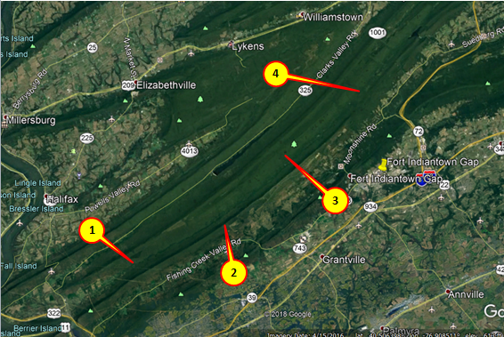
Point #1 Dauphin Trailhead [LAT/LONG 40.403231 -76.835176]
Point #2 Old Horse Shoe Trail intersection with the drop into Stony Valley [LAT/LONG 40.417893 -76.744742]
Point #3 Cold Springs Trail Head [LAT/LONG 40.477027 -76.626333]
Point#4 Rausch Gap and Rairoad junction
Peter’s Observations:
No other Creek that I am aware of allows such a long stretch of wilderness that is easily accessible. Stony Creek does get a lot of fishing pressure the first two weeks of trout season, but the nothing compares to the possibilities to discover in Stony Valley. After May, you can go an entire day and not see a soul. If you get back on the right weekend in May, the Dogwood blooms are overwhelming. By June, many fishermen shift to small mouth bass and larger game fish on the Susquehanna and other bodies of water. That leaves Stony open. Enjoy the solitude but be careful. This is one of the last places on the East Coast where you can really be alone.
There are so many options in Central PA, but to me Stony Valley has the top spot.
Fishing Stony Creek:
For Early Spring fishing or late Fall, streamers work well. Fishing near the stocking dates will increase your chance of catching fish. Nymphs work all year long. Hatches present opportunities for dry flies if you can match the hatch, but they need to be weighted to reach the deeper holes with a fast current. For spin casting, rooster tails are always produce. When all else fails, go to worms. Keep a small shovel on your belt and dig them up near the stream bank. Stony offers many holes containing deadfall and cover. Fall pools are rare to find. Plenty of large rocks to create eddys where trout like to hang out waiting for a meal. Every bend presents a new challenge. Take lots of tackle because the hemlocks love to keep anything that lands in their branches. Chest Waders are almost a requirement. I’ve used hip waders in the past and always had to sacrifice presentation for casting location.
There are places on Stony Creek where you might be the only fisherman that season but you have to penetrate deep into some tough vegetation in the bogs and swamps. I recommend fishing in pairs when venturing into those locations.
Timing:
The water remains cold deep into the summer but is susceptible to mine drainage from old sites. Some natives survive the stress presented by the mining drainage but heavy fishing pressure makes catching a native rare. Local organizations have done tremendous work in treating the drainage from the old mines. After July, the fishing gets hard.
Just be aware of the black flies in the summer starting in June. They hang around until the first frost in September. They are relentless.
The first three weeks of fishing in the Spring can find a lot of fishermen on Stony. After that, the pressure reduces as many outdoorsmen shift focus to Spring Gobbler season. This brings the unique opportunity to hunt turkey in the morning and fish for trout in the afternoon. Now that’s a good day.
LOGISTICs:
Lodging: I-81 has plenty of hotels running from Harrisburg to Pine Grove.
Food: Dauphin has several establishments to include fast food to Bar Food by the Creek in Dauphin .
Tackle: Bass Pro shop is located in Harrisburg on US 322. Plenty of small tackle shops to include TCO are found all over Central PA.
Emergency Planning:
- Do not expect Cell Phone coverage beyond theTrail Heads.
- Carry basic emergency kit and signal whistle.
- Watch the weather for extremes.
- Store food at camp sites accounting for bears.
- Basically, think things through because help is no where near by.
- Take a buddy. Do as I say; not as I do.
- Carry water or a means to purify water.
Another great blog post! I highly recommend Stony Valley, PA to anybody, amazing place!
Thank You Matt!