 bluecordfishermen
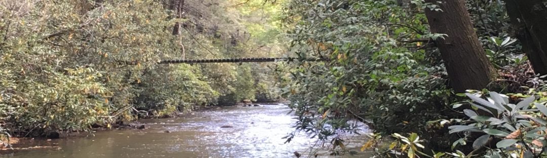
Lunker Hole Pond Fort A.P. Hill
Lat / Long: 38.121290 -77.353914
Description
Lunker Pond is a pond formed from a dirt road on a causeway crossing a creek. Located on the North half of Fort A.P. Hill, west of the road intersection of A.P. Hill drive and Honeysuckle Gate Road. This lake is about 55 yards
wide and 365 yards long. The east bank is very steep. The west bank is less steep but the channel runs closer. Lilly pads line both banks and there is a lot of submerged timber. The old dam breast is 25 yards from the dirt road that runs on a cause way over the draw. The causeway forms a second earth works with the ground between them being boggy but walkable if wearing waterproof boots. Storms over the past several years have washed out the cause way where the culvert ran under the road. The portion near the feeder streams is very shallow.
https://bluecordfishermen.com/fort-a-p-hill/
Editor’s Observations:
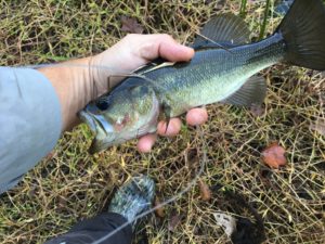
Lunker Pond in the Fall is my favorite fishing hole. There are a few large pickerel so consider leaders for lures. I have lost more tackle to pickerel on Lunker pond than to the submerged logs. I have caught more big bass on Lunker pond than any other body of water that was open for fishing. Some of the sunfish are very big. My observation: Lunker Pond is home to a large number of fish eating birds whether they be of the herring family or birds of prey. Large hawks, king fishers, and eagles are all part of the package at Lunker Hole. The fish have to have cover to survive and they will not be in open water unless its deep. Every submerged log is a potential trophy bass.
Access:
Fort AP Hill is a closed post and has traffic control points to control who gets on the installation. This limits pressure on the fishing. Fishing permits are required. It’s a requirement to log in electronically to the iSportsman website to clock in as well as when you depart. Failure to do so will lock you account. There is no buffer for the not later than time to check out. Checking out also includes reporting your catch by species for that day. The installation management sets these rules. See the Fort AP Hill Info page for details.
DIRECTIONS:
Lunker Pond is found using unmarked, secondary dirt roads. Since the dam was washed out some time between 2015 and 2017, each bank requires a different route. The breach in the causeway is NOT EASILY crossed on foot. I have never even attempted crossing this gap. The North bank is reached using the dirt road starts at Point #1. Several options will get you to point #2 (Lat/Long 38.122273 -77.353944). At point #2 parking is available amongst the trees. You may need to clear the road from fallen timber attempting to reach point #2. To get to the southern bank, follow Honeysuckle Gate Road to Point #3 (Lat/Long 38.114529 -77.342923). Point #3 is 0.8 miles from the intersection of A.P. Hill and Honeysuckle road.
Directions for Lunker Hole Pond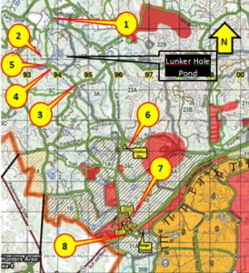
Point #1 Is the start of the route to the North bank of Lunker Hole Pond. This access is off of AP Hill road. There is no sign. Pick up the dirt road heading North past Fish Hook Lake. Intersection is on top of a low hill.
Point #2: Road intersection near north side of causeway. Parking space is available. 2 (Lat/Long 38.122273 -77.353944)
Point #3: Is the start of the route to the South bank of Lunker Hole Pond. This access is off of Honeysuckle Gate Road and is not marked. Use careful navigation to find this dirt road. Lat/Long 38.114529 -77.342923)
Point #4: Road junction on high ground overlooking the dam breast and cause way. Plenty of space to park near this intersection. Keep vehicles off the cause way. This is self-explanatory upon arrival.
Point #5: Huge gap in cause way that is a significant obstacle. Climbing down and up the other side is sketchy at best.
Point #6: Outdoor Recreation Office. Kayak and canoe rentals available. This office also handles the lodging on post.
Point #7: Wildlife Management Office and the best place to get a post permit to fish.
Point #8: Entrance off US Highway 301.
Launch Site: There is not good launch site. You have to fight the brush or terrain to get a kayak into the water.
Bank Fishing:
Lots of Lilly pads and brush. Some of the bank is swampy. As my Dad would say, that bank looks “snakey”. Cold Spring and Fall mornings make getting to the water easier because you can bravely walk through the “snakey” parts. There are parts you can get to and fish through the Lilly pads, but count on losing some tackle. Either you will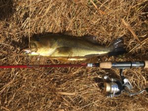 Fall snag on a log, lilly pad or bush at some point. If you hook a smart one, they are heading for the lilly pads. I had one nice bass that I watched swim around a sunken log and got away. From the bank you can reach spots with sunken logs easily. If the weather has been dry, the low water will leave a bank that is walkable if you wear rubber boots/duck hunting boots. Fly fishing off the old dam breast is possible if the ground is firm enough to walk on. See Hot spot map for details. Otherwise its near impossible to fly fish on Lunker Hole Pond.
LUNKER HOLE HOT SPOTS
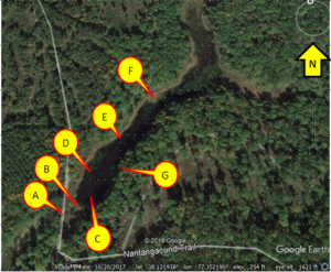 A: Breach in Causeway
B: Original Dam Breast
C: Deep Hole prior to dam
D: best combo of submerged timber, depth and lilly pads
E: Fallen Tree
F: Marshy pennisula if the weather is dry. Pickerel all around.
G: East/southern bank has numerous locations of submerged logs
Timing:
Early Spring is great for bass protecting their nest near the lilly pads along the bank. Fall is good to get those fish feasting on their last meals before the cold slows them down. See the note above why cold mornings are great to get your courage up to share the shore with the snakes. I also think the fishing pressure is reduced with outdoorsmen focusing on hunting or football and not fishing. Early Mornings are best but you can be very successful during the evenings. Summer really slows down activity but you can still catch fish. Take ant floaters in the Fall/October just in case you are on the water when the ant hatch flies from their nest. Pickerel in the Fall is worth the trip.
LOGISTICS:
Lodging: Fort A.P. Hill is in rural VA. Several local hotels are near by but even I haven’t stayed in them. Post MWR (Morale Welfare and Recreation) runs the lodging and they have comfortable rooms for cheap (30-60 per night). Camping is available and the camp sites have electric hook ups and a lodge with washers and dryers are inside. Tent camping is $5/night.
Food: Home cooked Breakfast and Lunch is available at the New Yorker Restaurant that is on US 301 between Fort AP Hill and Bowling Green. Closest town is Bowling Green. Two Italian restaurants, a subway, Pizza Hut and a Grocery store are your options. A small shopette runs on random hours on Post at Camp Wilcox cantonment area (Lat/Long 38.1038 -77.2922).
Tackle: Bowling Green has a great tackle shop: MIKE’s Outdoor Shop, 113 Milford street Bowling Green VA 22427 Phone # (804) 633-2660.