 bluecordfishermen
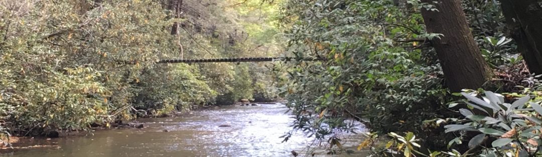
South Mills River, Hendersonville NC: Lat / Long: 35.404591 -82.661211
Background:
For my second back country fishing trip, I chose South Mills River. Western North Carolina has many alternatives to choose from near Asheville. Alternatives near Asheville are Avery Creek and Davidson River. Several articles and blogs provide some limited background which made selection challenging but there few bad choices. The top factor to consider is a trailhead that is within striking range of a river. Turkey Pen Gap provides an excellent jumping off point. From Turkey Pen Gap you can be fishing in 30 minutes. A valuable source on trail heads in western North Carolina is:
https://www.hikewnc.info/trailheads/
Description of South Mills River:
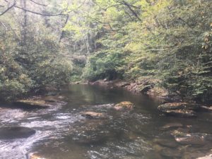
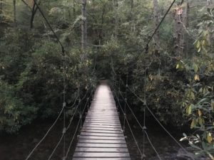
South Mills River is a medium size mountain stream in Pisgah National Forest that runs North East towards Asheville and empties into the French Broad River. South Mills River is designated as wild trout water. Near Turkey Pen Gap the South Mills River is about 20 to 30 yards wide. There are a few fall pools but mostly the river is a steady flow between fall rapids. There is a suspension bridge where the trail comes off Turkey Pen Gap and gets you on the north shore. All other crossings require wading through knee deep water that was still brisk in the summer. The banks are covered in mountain laurel and near impenetrable. The challenge is to find an opening in the mountain laurel to enter the stream and work your way carefully up or down stream. On the first day, Saturday, I met very few people. I account for this to either college football or the out doors men choosing to hunt turkey. The second day was a Sunday and the number of people I met were close to thirty. Most were hiking but enough were fishing to cause competition for pools. On many fishing articles and blogs, South Mills River makes the top 10 trout streams in North Carolina.
Peter’s Approach:
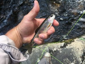
I parked at the trail head and was moving down the mountain before dawn. I decided to go down stream from the suspension bridge, pick a base camp and fish from there. I crossed the river three times and picked a small ridge (finger) near the intersection of Bradley Creek and South Mills Creek trails for the base camp to drop ruck. After I dropped the ruck sack, I hiked up Bradley Creek Trail to the top of the mountain for no good reason other than to see the top.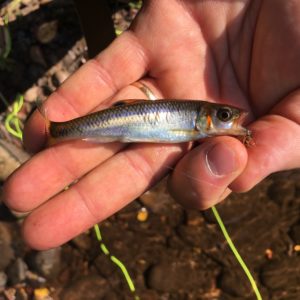 After returning to my rucksack, I gathered my fishing kit and walked down stream another mile to a spot that I could enter the river. Before lunch, I had my first fish. It was not a trout but a small shiner. I fished up stream to some fall pools and caught my second. This one was a decent size brook trout (8 inches +/-). South Mills River is reported to have some large brown trout in addition to the brookies.
Fished until dark and set up camp. That night I smelled no camp fires and only heard sporadic camp noise about ½ mile away just after dark. Since it’s a national forest, I ran a cold camp. The Fall temperatures are cool but not demanding of a fire. The valley is remote enough to know you are by yourself. Next morning I fished a bit and then packed up. I cached my ruck near the suspension bridge and fished up stream. Moving up stream I came across a paid guide instructing a young women on fly fishing and at that point I knew I was in the right spot. About 300 yards up stream from the suspension bridge is a terrific camp site that sites on a horse shoe bend in the river. A large deep pool is adjacent to this site forming a peninsula for the camp site. I missed two in this pool. Beyond the horse shoe bend the trail disappears into a maze of mountain laurel. I entered the water after finding an “opening”. This was a fight to get through the mountain laurel with a rod and tackle but once in the water its worth the effort.
After wading for several hours it was time to get out and warm up. I had no luck but could see small brookies swimming around my legs. By this point, it was past noon and the number of people between me and the suspension bridge became a surprise. Every other pool had a fishermen. Near the suspension bridge the fishing pressure resembled what you may find in Central Pennsylvania stream in the spring. In addition to the fishermen were several riders on a trail ride, hikers and one kid coming down the mountain on a unicycle. It was time to ruck up and climb up the mountain to Turkey Pen Gap.
Access:
Navigation from near the Asheville Regional airport to the road leading up to Turkey Pen Gap is easy just following NC 280 off of I-26. The dirt road heading up to Turkey Pen Gap gets rough. An SUV or 2x wheel drive truck is fine, but a low road clearance sudan is going to bottom out along the way. The road up to Turkey Pen Gap passes through private land so please adhere to the signs.
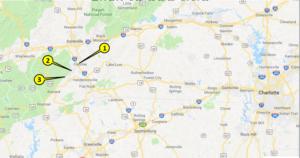
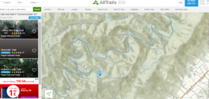
Point #1 I-26 and VA 280 Boylestown Highway
Point #2 Boylestown Highway (280) and Haywood Road
Point #3 Intersection of VA 280 and Turkey Pen Road LAT / LONG: 35.328938 -82.646371
The hike from the trail head at Turkey Pen Gap down to the suspension bridge is easy. The trail narrows but is not a challenge by any stretch. Once hiking on the South Mills trail, anticipate crossing the creek several times. The water is swift and the bottom rocky but fordable if care is exercised. I saw one man fall in during his crossing and it was a rough way to start his hike.
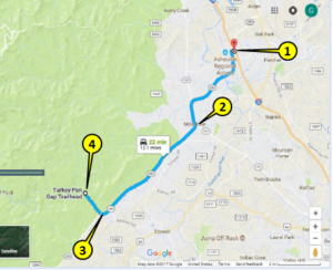
 Point #4 Trail Head at Turkey Pen Gap LAT/LONG 35.342616 -82.659248
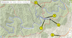
Point #5 Suspension Bridge over South Mills River
Point #6 Base Camp Site near Bradley Creek and South Mills River Trail intersection
Point #7 Horse Shoe Bend / peninsula north west of suspension bridge
Peter’s Observations:
South Mill’s River was a treasure being so close to Asheville and Hendersonville NC and that is no secret. Turkey Pen Gap parks full pretty quick so you need to get there before day break on a weekend.
The South Mills River Valley is an easy hike down the mountain. The return climb of 250-feet takes 10 minutes. This small barrier combined with the large trail head make the valley inviting to a lot of people. As a result, South Mills River gets a lot of fishing pressure. Fishing was challenging among the Mountain Laurel lined shores. My luck was not great (two fish) but just being there and giving it a shot was worth the effort. If I return, I would hike a lot farther to get a buffer between the majority of the visitors and myself. The best route looks to be Vinyard Gap trail that follows the ridgeline east of Turkey Pens Gap and drops down into South Mills River.
Fishing South Mill’s River:
This is a catch and release area and limited to artificial lures only. 3 or 4 weight fly rod is more than enough for this mountain streams. A 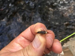 short rod is better (7’-6”). Nymphs were my choice. I tried dry flies in the evening but only a couple of strikes by very small fish. The mountain laurel is unforgiving. Take plenty of tackle and plan on losing half of it.
Timing: Evenings are good for dry flies. Nymph’s can take fish anytime during the day. I caught my one trout around 3:00 PM using a nymph. Timing really needs to apply to hitting South Mills River when hiking traffic and fishing pressure is reduced.
LOGISTICs:
Minimal considerations. Anything you could need is found in Asheville depending on which way you approach South Mills River. Hendersonville has a lot of small establishments. Small towns closer to South Mills River are tourist towns and have some small bait shops.
Lodging: Asheville has every imaginable hotel franchise and price range. Pisgah National Forest allows camping without permits but no fires.
Food: You are limited to what you pack in. Consider how you store food with respect to wildlife (bears).
Tackle: Asheville has Dick’s Sporting Goods (329 Airport Rd, Arden, NC 28704) and many other retailers.
Emergency Planning:
- Do not expect Cell Phone coverage beyond the turn off for the Turkey Pen Gap.
- Carry basic emergency kit and signal whistle.
- Watch the weather for extremes.
- Store food at camp sites accounting for bears.
- Basically, think things through because help is no where near by.
- Take a buddy. Do as I say; not as I do.