Lat / Long: 35.165188 -79.102980
Description:
Kiest Lake is a managed for Bass and located South of Manchester on Fort Bragg. The dam breast can be seen from Manchester Road. This lake is about 140 yards wide across the dam breast and 450 yards long from the dam to the feeder creek. Although managed for bass, it contains sunfish, and pickerel. In the spring, aquatic grass goes and makes spinning lures difficult. By prime bass season, the grass is gone. There are several man made islands, peninsulas and rock piles in the lake. The best one is located on the west side near the boat ramp and close enough for bank fishing. East side is very shallow and unproductive.
https://bluecordfishermen.com/locations/fort-bragg-nc/
Editor’s Observations:
Kiest Lake is great if you live on Post and want to get on the water fast. I never had any luck along the dam

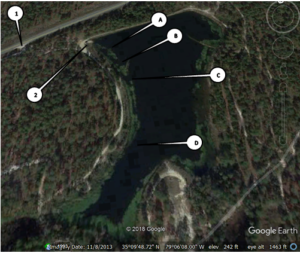
breast or east side but I have witnessed fish caught near the structure the controls the drain pipe. I have seen large pickerel near the artificial structures on the west side so consider heavy leaders for lures. I have not caught any bass over 15 inches out of Kiest but certain that I missed one or two large ones. Some of the sunfish are very big. On many trips I never got past the man made island because it was productive. At the end of the evening, the hot spot marked A “always” produced (80%of the time) pan fish or bass at dark before getting out of the kayak at the boat ramp. If you are on Kiest Lake at the southern end near dark, expect the beavers to visit and attempt to chase you out of their territory.
Access:
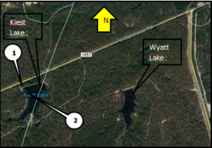
Keist Lake is outside the secure area of Fort Bragg and accessible by public roads. The entrance to Kiest lake is 1.3 miles west of the intersection of Lamont and Manchester roads. The dirt road starts at Point #1 and traverses a slight rise to take you to the NE corner of the lake. The road continu

es over the dam breast to the west bank.
Point #1 is the access off of Manchester road. It is marked by a sign.
Point #2 is boat ramp
Launch Site: Launch is on the NW corner adjacent to the dam breast. This boat ramp is big enough for trailers and john boats. There is plenty of room for parking near the boat ramp. Additional sites for kayak launches area around the lake where beaches have formed by erosion run off from the fire breaks meets the lake bank. Southern end of the lake has a large beach and reachable by truck or 4×4 SUV.
Bank Fishing: Only a few sites allow access to the lake. Dam breast is usable for fishing. Because it is near main post and easily accessed from Manchester Road, bank fishermen keep a lot of pressure on the lake. The beaches formed from erosion run off offer access to the lake.
Timing: No surprise here. Early Spring through June is good. April was the best month. Mornings are good. Last hour of light is the best time. If a hurricane is projected to hit the Fort Bragg area, Fort Bragg management will lower the lake level to take on the storm. In 2017 this happened to several lakes on Fort Bragg and the hurricane did not impact the area. This left the lakes with a very low water level in August and September. This left Kiest lake with 20 feet of mud flat. Launching was near impossible during this period. This very low level exposed the artificial structures on the west side of the lake.
HOT SPOTS
PICT #2

A: Rock structure. Lots of pan fish.
B: Rock Structure and hole on west side of man made island. Productive.
C: Relatively deep hole on east side of man made island. Very productive.
D: Lots of stumps and the channel. Great for sunfish and bass.
 bluecordfishermen