 bluecordfishermen
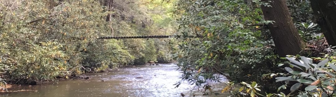
Lat / Long: 35.184027 -79.25778
Description:
MacArthur Lake is a managed bass lake located on the west end of Fort Bragg along Manchester Road. This lake’s dam breast can be seen from Manchester road.
This lake is about 285 yards wide at the northern end and 915 yards long on the west side. This size makes for some excellent cardio workout as well as fishing. MacArthur Lake contains sunfish, bass, catfish and pickerel. This lake has a tremendous number of stumps with many of them submerged just below the surface. There are several places to launch kayaks but formal boat ramps do not exist. Boats can be launched off trailers at two locations. This lake has a lot of submerged logs, stumps and shore vegetation to focus on. I have not had any luck on the dam breast or near the spill way. The channel follows the western shore and is pronounced in the southern half of the lake. (Based on anchor depth over several months)
Editor’s Observations:
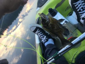
MacArthur Lake offers a wide range of fishing holes. Because of the size of this lake, if you have little success at one spot, paddle over to another and change your luck. This lake has plenty of structure and stumps on the South and East side. Some of the sunfish are very big. In the Spring and early Summer, I never was skunked on MacArthur Lake until July. Fish did become very fickle in the deep summer and I would experience many misses. Of all the lakes at Fort Bragg, I would label this as my favorite. Beavers will entertain you in the evenings to the point of becoming annoying/aggressive. If you are kayaking, they sneak up behind you and slap their tails. That will make you flinch.
Access:
MacArthur Lake is outside the secure area of Fort Bragg and accessible by Manchester road (public road). Two dirt roads provide an entrance off Manchester Road as n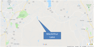 oted below at point #1 and #2. During the summer, military units will bivouac near the open fields and limit access to that side of the lake. The other access point allows fishermen to share the lake with units conducting training.
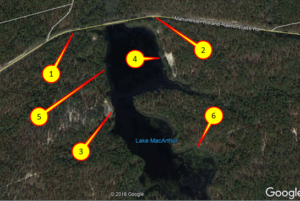 Point #1 [Lat/Long: 35.185849 -79.260650] is the access off of Manchester road on the west side of the lake. It is marked by a sign.
Point #2 [Lat/Long: 35.185939 -79.256237] is the access point on the east shore of MacArthur Lake
Point #3 is the boat ramp.
Point #4 is boat access.
Point #5 and Point #6 are kayak launch sites where beaches are formed from erosion off of the firebreaks.
Launch Site:
The best launch site depends on where you wish to fish. Parking available near the locations indicated by Point #3 and #4. Both are open fields with sand roads. Sand can get soft/deep in some places. All around the lake, there are many options to launch Kayaks off the beaches that are created by erosion coming off of firebreaks.
Bank Fishing:
Numerous sites allow access to the lake for bank fishing. The dam breast is usable for fishing. Although there are numerous locations to fish off the bank, these may all be occupied on Spring days.
Timing:
No surprise here. Early Spring through June is good. April was the best month. Mornings are good. Last hour of light is the best time. July and August slows down. I have caught fish between 1000 and 1300 during the late spring.
HOT SPOTS
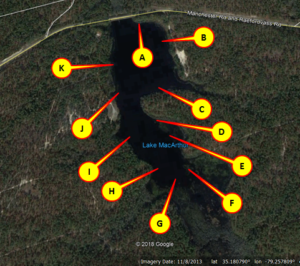 Point A: Sunfish and Bass are in the vegetation that hangs into the lake. The entire stretch of shore has submerged logs
Point B: A very large log is submerged and has a branch sticking out of the surface. I’ve missed a very large bass here twice and caught smaller ones nearby.
Point C: Productive in the late evening. This was often my last stop before heading to the launch site on the eastern shore.
Point D: Very Similar to Point A. Caught Crappie here in the spring. Sunfish are in the vegetation.
Point E: Stumps and bass
Point F: Lots of Stumps and bass. Best in the spring when the water is higher
Point G: Favorite part of this lake. Lots of stumps that keep out the john boats and give kayaks access to lots of bass. Caught several nice size bass in this area. The closer you can get to the swamp at the southern end the better the fishing.
Point H: More submerged logs with some stumps that lie just beneath the water.
Point I: Submerged logs. Channel is very pronounced in this area.
Point J: Isolated Submerged logs that lie off the shore.
Point K: Isolated Submerged logs lying off the shore.
Spillway that is at the northwest corner has never produced a strike. Looks great for pickerel but never had a single strike.